ABSTRACT
Intelligent modelling technologies such as digital twins, applied to urban infrastructures and systems, can enhance community-centric planning by simulating urban environments and developing predictive scenarios in response to critical and uncertain situations, allowing both optimal planning and aided or even automated real-time decision-making. This paper revisits the main methodologies and some proofs of concept developed within the DesCartes program leaded by CNRS@CREATE, with active contribution by Duoverse.
Key Words: Hybrid AI, Hybrid Twin, Critical urban systems, Smart cities
1. INTRODUCTION
Urban systems today face growing challenges, from climate uncertainty to rapid urbanization, requiring more adaptive and responsive planning tools. Among the most promising solutions are digital twins—virtual representations of physical assets or systems—that allow cities to simulate, anticipate, and respond to changing conditions in real time. These technologies provide a powerful foundation for enhancing decision-making, from the design phase to real-world operation.
However, building accurate and efficient digital twins presents challenges. Traditional physics-based models rely on well-understood equations to simulate behavior, but they can fall short over long time periods or under unexpected conditions. Meanwhile, data-driven models require large amounts of high-quality sensor data, which can be costly or difficult to obtain in urban environments.
A promising alternative lies in hybrid modelling, which combines the strengths of both approaches. Rather than building a model purely from data, this method uses real-world data to refine and correct physics-based predictions. This approach not only reduces the need for extensive data collection but also retains interpretability and trust in the model's physical foundations.
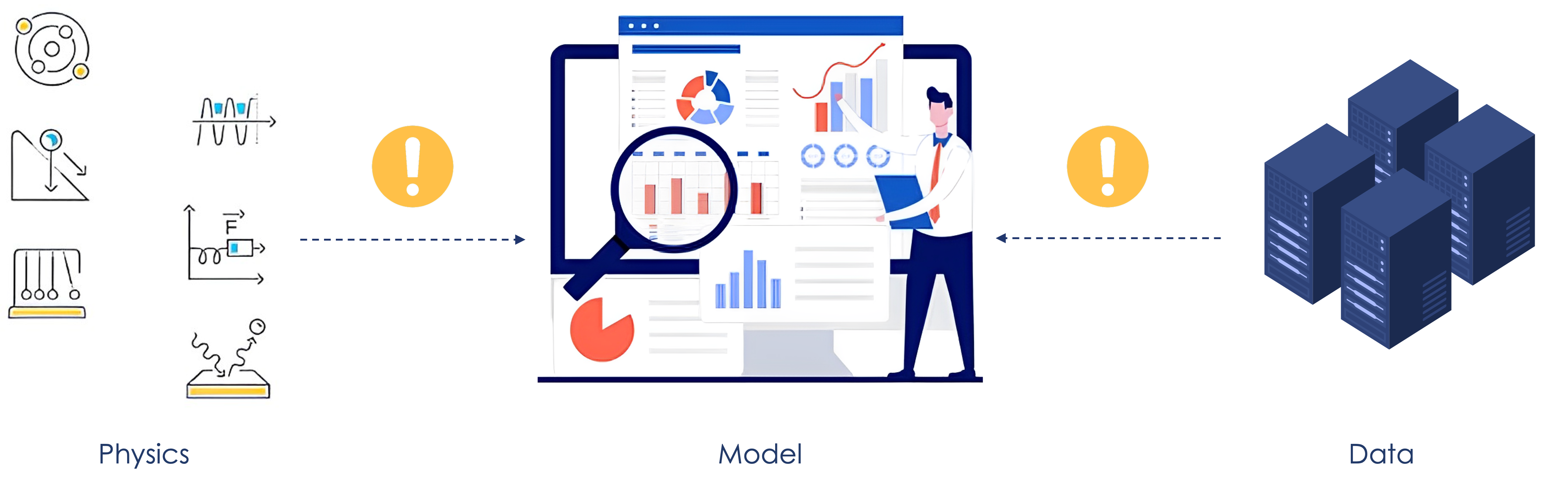
Moreover, physics-based knowledge doesn't just improve the accuracy of digital twins—it also helps guide data collection. This is known as active learning: instead of gathering data randomly, we use our understanding of the system to decide what to measure, where, and when.
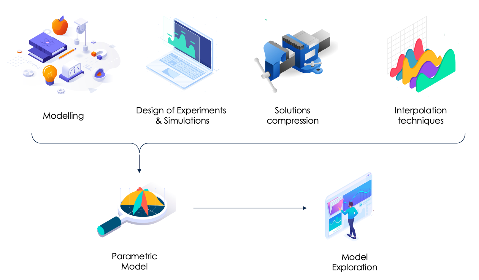
In hybrid modelling [1-3], we combine physics-based simulations with machine learning to build fast, accurate models. The process works roughly like this:
- We start by choosing the model and its parameters (the variables we want to explore).
- We run simulations for different combinations of these parameters (this is called a Design of Experiments, or DoE).
- Each simulation gives a detailed solution—how the system behaves under that scenario.
- These solutions are then simplified using compression techniques (linear or nonlinear, such as PCA or autoencoders, respectively) which help reduce complexity while preserving essential features.
- Finally, we use machine learning to learn how the compressed solutions depend on the parameters, enabling quick predictions for new scenarios.
To improve accuracy, we also compare real-world measurements with model predictions. The differences (called gaps) are analyzed and learned as well. We then combine the physics-based predictions and the learned corrections to form a hybrid model—accurate, fast, and explainable.
This approach makes the most of both worlds:
- Faster, because we use simplified surrogates.
- More accurate, thanks to the data-driven correction.
- More efficient, because it needs less data overall.
The workflow may be summarized as in Fig. 2.
This new knowledge/data alliance enables real-time diagnosis, prognosis and decision-making, using less data (frugality) with better accuracy in predictions, it remains almost explainable, and minimizes the ecological footprint (sustainability). By enabling human-driven updating of knowledge and security certifications, it also enables a human centric approach where the privacy of citizens is ensured.
Through Hybrid Artificial Intelligence (HAI), different technological functionalities can be elaborated and, subsequently, closely combined for constituting the complex system of systems emulating the city functioning within its environment.
This new paradigm is applied to several case-based solutions for critical urban systems, where environmental maps (wind, pollution, temperature etc.), digital energy, and smart sensing of large critical civil and industrial infrastructures, are assimilated to perform predictive maintenance, optimize energy production and distribution, and enhance crisis and emergency management, ton in essence contribute to the life quality, pleasure and safety of citizens.
2. TOWARDS A CITY HYBRID TWIN
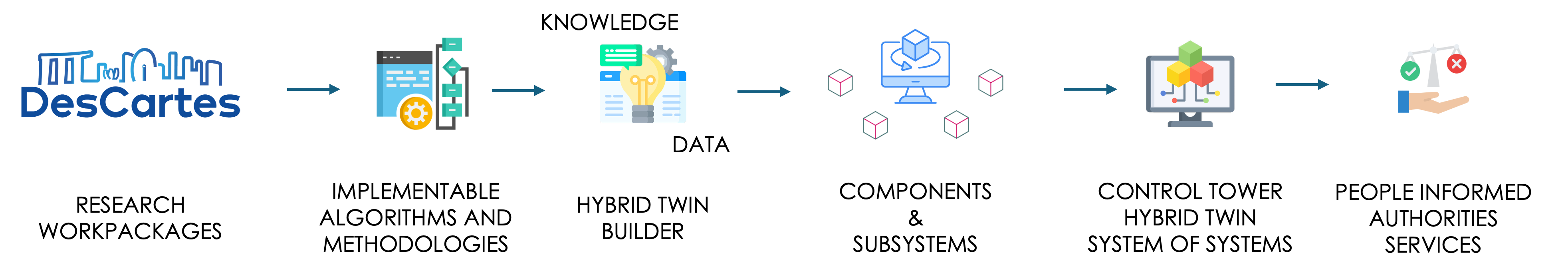
The integration workflow is sketched in Fig. 3 where the fundamental research gives rise to implementable algorithms, that integrate the so-called hybrid-twin combining surrogates of physics- based model (able to operate under the stringent real-time constraints) with data-driven models of the prediction to measurement biases (the gap or physics-based model ignorance), most of time consisting of informed learning.
These hybrid twins are then applied to model the different system components, that at their turn are integrated in the so-called “control tower”, the system of system hybrid twin, that could and should be advantageously employed for taking decisions, and eventually informing people, governmental services and authorities, able to proceed with optimal operation or with mitigation procedures in case of emergencies.
A proof of concept is being developed within the DesCartes research program, that the French CNRS is developing in its hub in Singapore, into CREATE, a NRF campus of excellence.
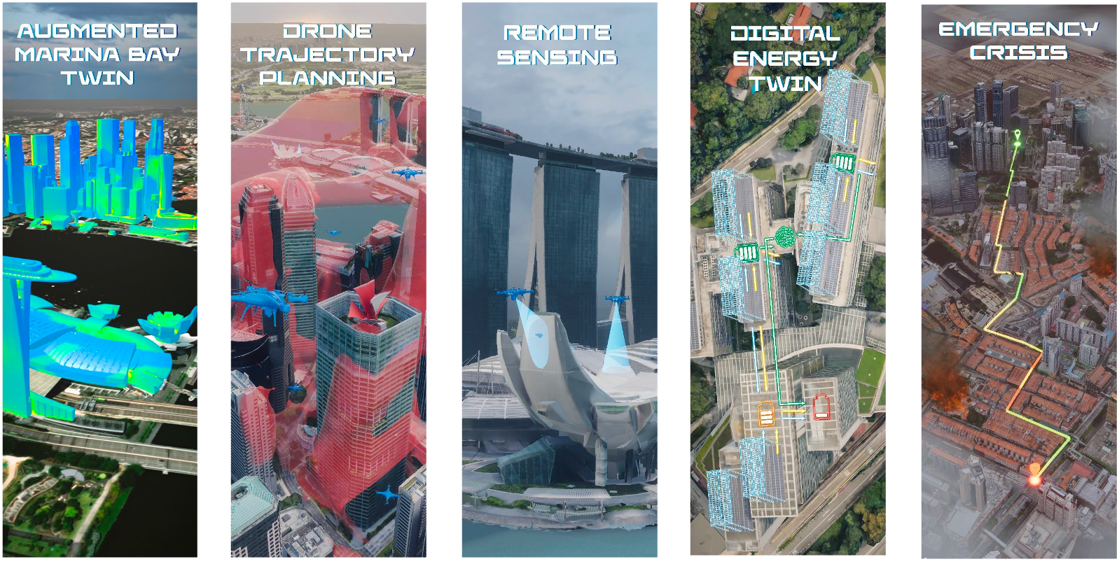
Descartes considers different demonstrators: (i) the city environment hybrid twin; (ii) the digital energy; (iii) remote sensing of large civil, urban or industrial infrastructures; (iv) drones trajectory planning, as the ones employed for monitoring, gods’ delivery, or mobility; and (v) management of emergency crises, as illustrated in Fig. 4, where the same rationale applies for the different addressed cases.
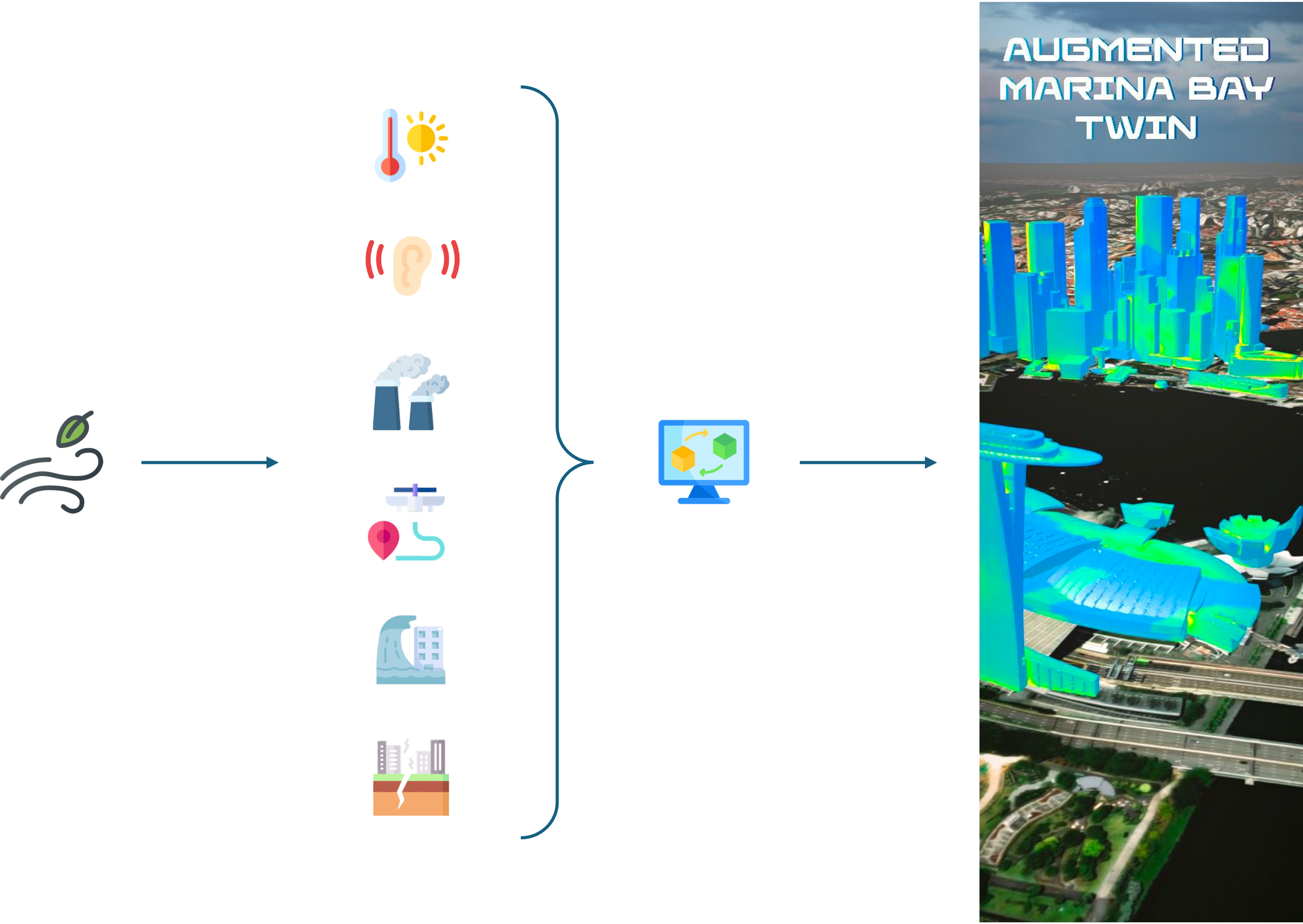
Concerning the city hybrid twin, applied to Marina Bay district (in Singapore) and La Defense district in Paris (France), the main protagonist was the wind, intimately coupled with many other physical phenomena (temperature, noise, air quality, plume dispersion, drone trajectory planning, ...) as illustrated in Fig. 5.
When focusing in a geographical area, at large scale, statistical data exists, grouped into the so-called wind-rose chart, representing the histogram of wind intensity and direction along a long period (years) to consider it representative (Fig. 6).
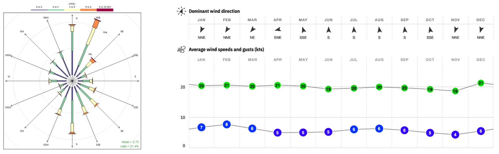
For nearby time predictions, weather forecast provides an estimation of the wind intensity and direction in a particular geographical area, as depicted in Fig. 7 for Singapore.
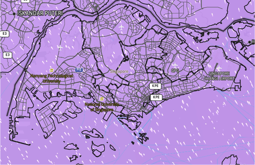
However, the scale concerned by the weather forecast (Fig. 7) remains too far from the one involved in the everyday life of citizens, the meter resolution at the street level, illustrated in Fig. 8.
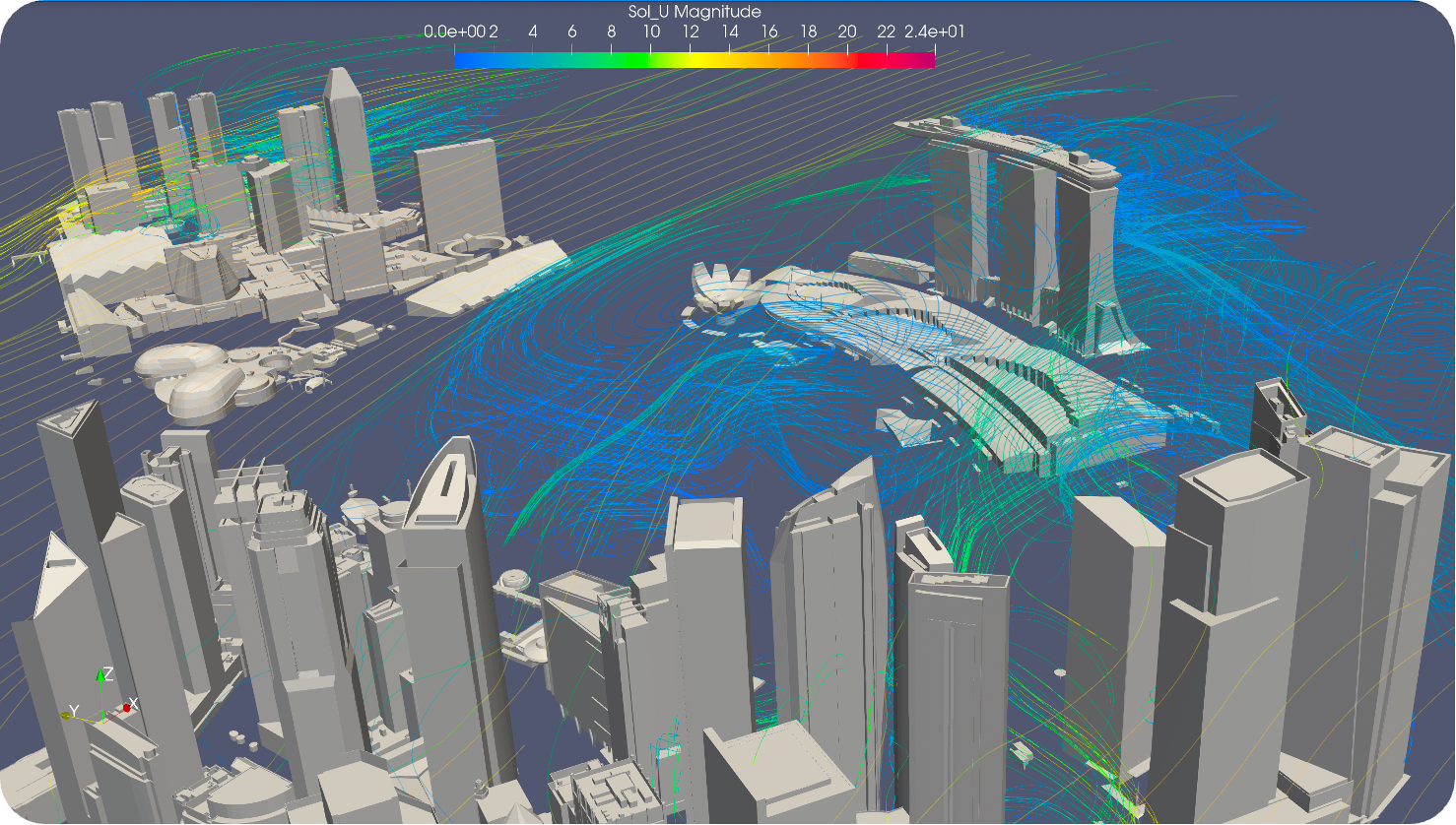
Thus, the question is how moving from coarse to fine scales in the wind representation, that is, how to obtain the wind field illustrated in Fig. 8 from the knowledge provided at larger scales (Fig. 7).
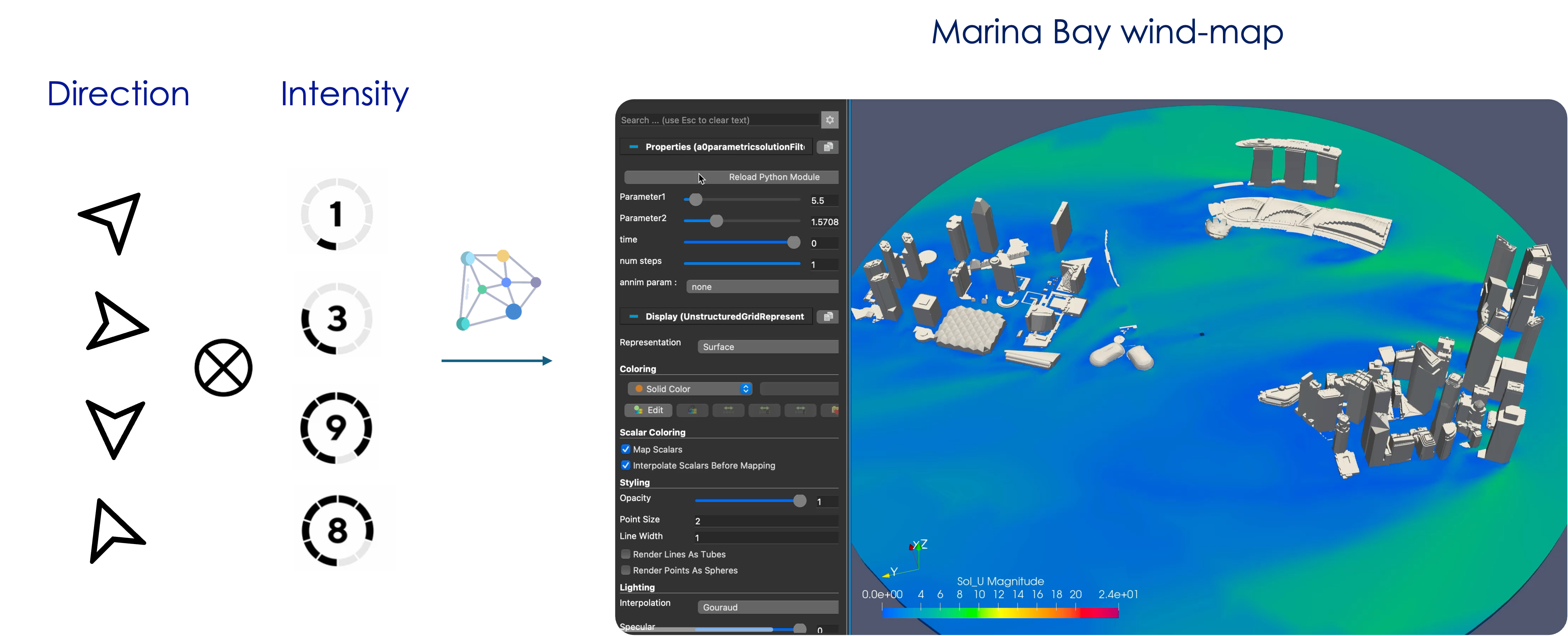
Following the rationale described above, the wind at large-scale is parametrized by its intensity and direction, considered as boundary conditions in the computational fluid dynamics model and its simulation. The DoE is defined by considering different wind intensities and directions, from which, the OpenFOAM CFD opensource software computes the different wind fields in the considered urban area. These solutions are then reduced by invoking a linear dimensionality reduction, the principal component analysis (PCA), on which, a regularized polynomial regression applies. To account the expected nonlinear solutions, rich polynomial nonlinear approximations are considered. However, to keep as reduced as possible (despite the approximation richness) the CFD computations, providing the data feeding the regressions, regularization becomes compulsory. Our simulations proceed with the velocity vectors to guarantee the incompressibility constraint of the regressed solutions, and an “elastic-net” regularization, that combines “ridge” regularization that prevents overfitting and “lasso” regularization that promotes sparsity, is used [4].
Even if in the present the model only involves two parameters (wind intensity and direction), to ensure the scale-up and then the possibility of operating in highly multi-dimensional parametric settings, separated representations for expressing the unknown fields are considered, with a greedy constructor that continues enriching the solution (adding modes) until reaching a small enough residual [4]. Fig. 9 sketches the DoE (left) and the real-time wind-map inference in the right.
When solutions exhibit parameter-dependent localization, usual approximations produce spurious effects, as a direct consequence of the so-called Kolmogorov n-width issue. To overcome this issue, nonlinear transformations enabling further reduction, or parametric optimal transport [5] can be applied.
The wind model could be enriched by adding to the wind intensity and direction and their fluctuations (amplitude and frequency) to compute the transient responses and their time statistics.
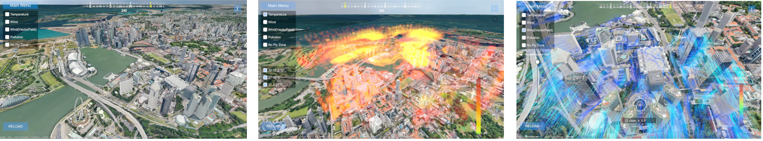
3. DERIVED REAL-TIME MAPS
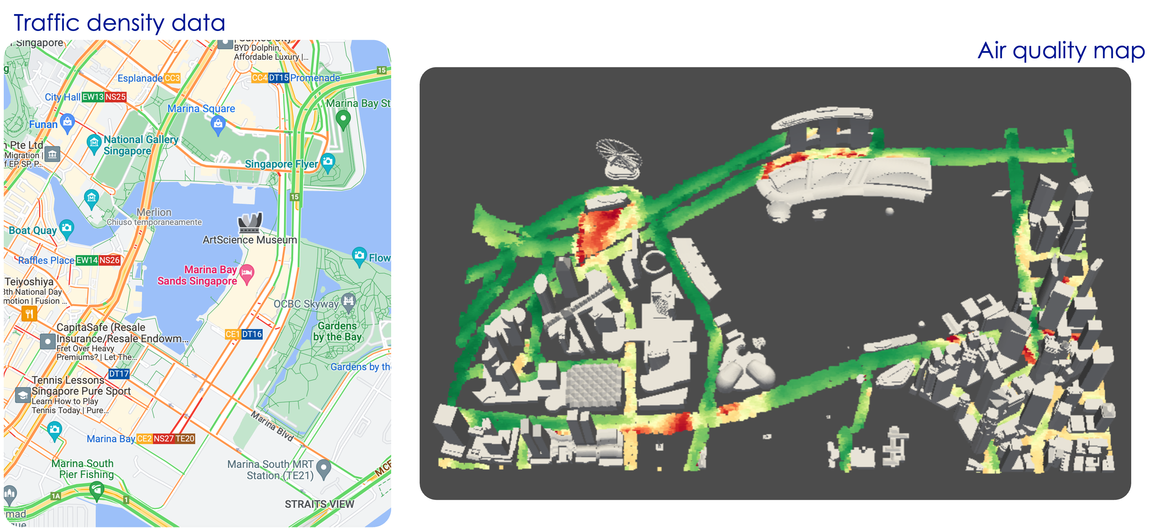
With the wind map available, different physics depending on it can be addressed. Air quality depends on the wind in each street, the density of traffic and the cars velocity distribution. By using state-of-the art models, the air quality can be estimated. The more expensive model input remains the wind field, but having the wind-map, enabling real-time particularization, the evaluation of the air quality performs almost instantaneously (Fig. 10).
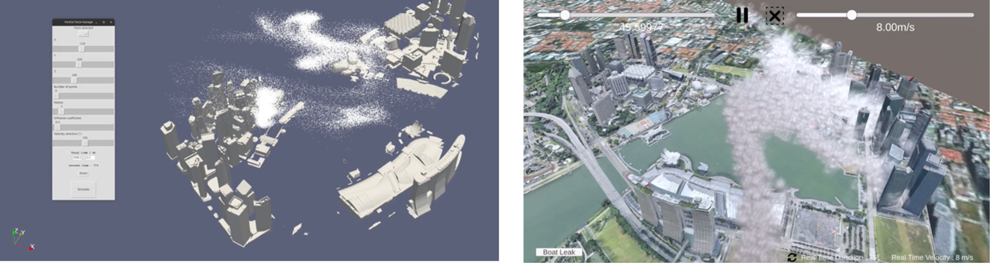
Emissions dispersion can be also easily evaluated from the wind map. As the wind-map can be particularized in almost real-time as just commented, now a passive-scalar representing the pollution concentration, can be dispersed by using a particles representation, by moving each particle because of the wind-induced convection and the stochastic motion representing turbulent diffusion. Thus, many scenarios can be simulated in almost real-time to take certified decisions (Fig. 11).
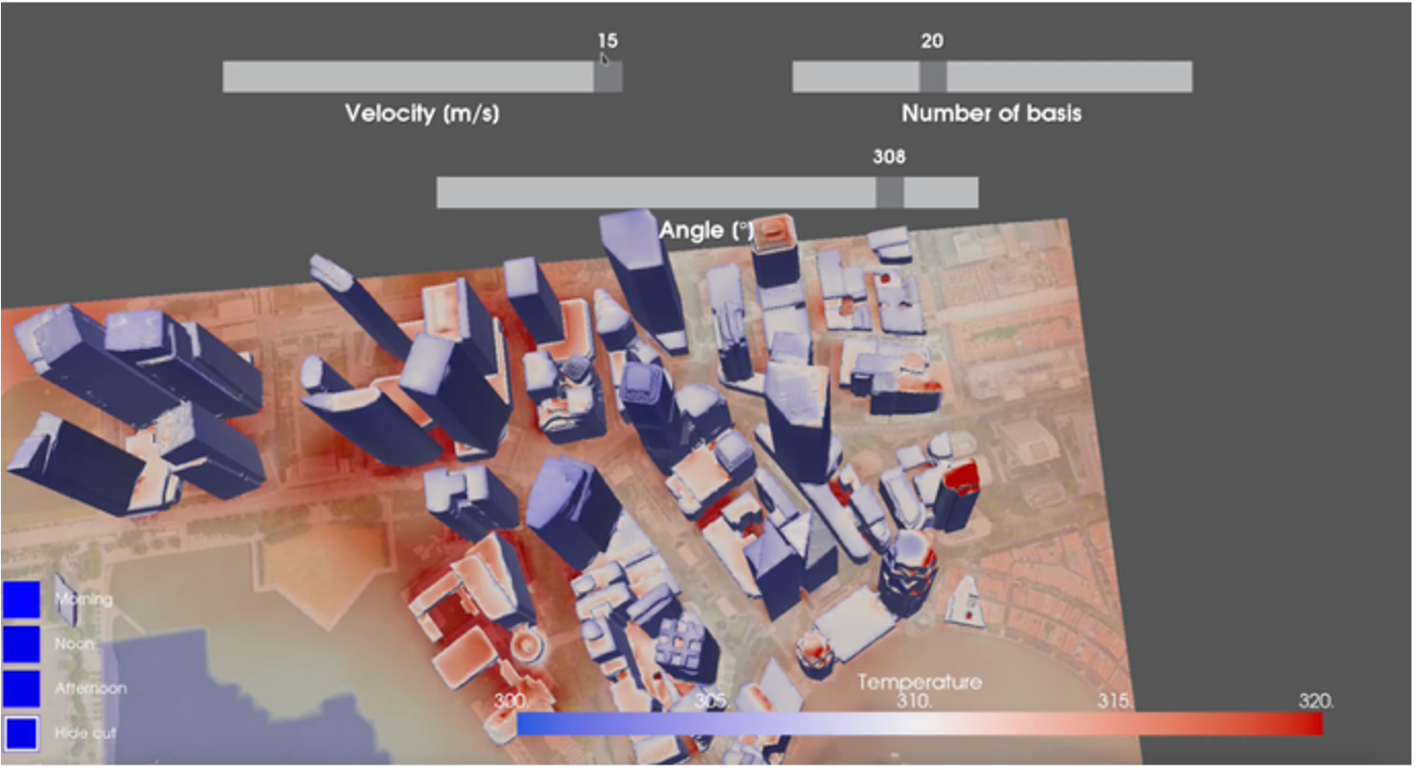
A temperature map can be elaborated by using the same rationale employed for computing the wind map, to infer, depending on the solar intensity and the wind conditions, the temperature at the ground and on the building’s walls, as well as the effects induced by temperature on the wind velocity field (thermo-convective flows).
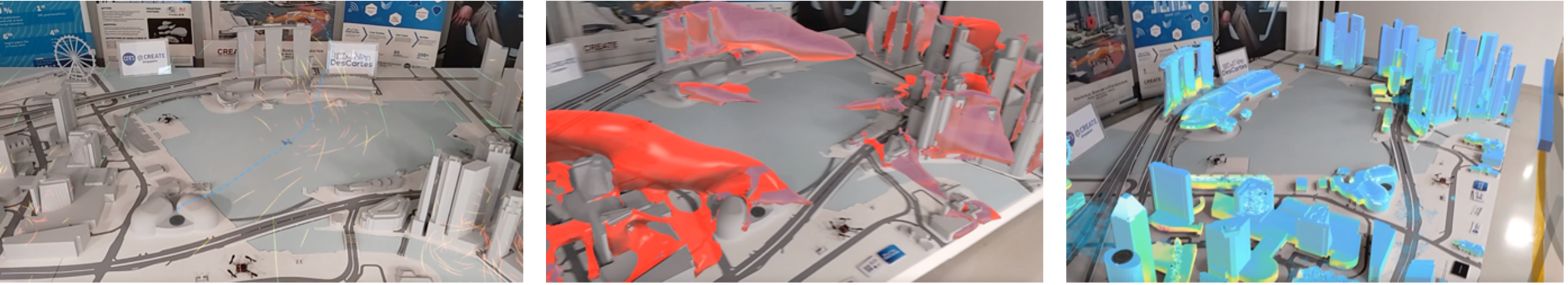
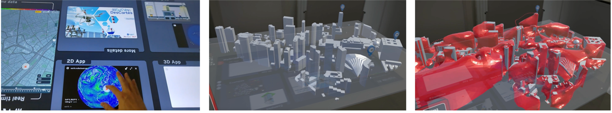
3. IMMERSIVE EXPERIENCE
All these maps can be use in augmented reality, in our case the Marina Bay reduced model, or in immersive virtual reality platforms, as shown in Figs. 13, 14 and 15.
4. CONCLUSIONS
Hybrid twins, consisting of physics-based surrogates enriched from data-driven models describing the prediction to measurement gap, constitute an opportunity for modelling complex systems of systems, where usual paradigms (fully knowledge-based or fully data-driven) fail to provide fast and accurate predictions, compulsory in optimal design and optimal operation.
This paper describes the main methodological concepts and computational procedures for advanced and efficient modelling. It also illustrates and discusses some proofs of concept addressed within the DesCartes program, leaded by CNRS@CREATE (Singapore), where hybrid modelling contributes to the real-time decision making in critical urban systems.
Now, large experimental campaigns are being defined to validate the physics-based predictions, and when needed, enriching them by associating the data-driven model of the noticed gap (deviation or ignorance), in close collaboration with different Singaporean agencies.
To keep posted about DesCartes, we invite you to visit the website https://descartes.cnrsatcreate.cnrs.fr/.
ACKNOWLEDGEMENT
Authors thanks the essential contribution of many colleagues: D. Baillargeat, V. Champaney, D. Di Lorenzo, B. Boris Huljak, A. Ammar, Kyaw Zin Htun, ... our industrial partners Immersion and ESI Group (part of Keysight).
This research is part of the DesCartes program, supported by the National Research Foundation, Prime Minister’s Office, Singapore under its Campus for Research Excellence and Technological Enterprise (CREATE) program.
REFERENCES
[1] Chinesta, F., Cueto, E., Abisset, E., Duval, J.L. and ElKhaldi, F (2020) Virtual, Digital and Hybrid Twins. A new paradigm indata-based engineering and engineered data. Archives of Computational Methodsin Engineering, 27, 105-134.
[2] Chinesta, F. and Cueto, E. (2022) Empowering Engineeringwith Data, Machine Learning and Artificial Intelligence: A Short IntroductiveReview. Adv. Model. and Simul. in Eng. Sci. 9, 21.
[3] Chinesta, F. and Cueto, E. (2023) Conciliating accuracy andefficiency to empower engineering based on performance: a short journey. CRAS,1-13.
[4] Sancarlos, A., Champaney, V., Cueto, E. and Chinesta, F.(2023) Regularizedregressions for parametric models based on separated representations. Advanced Modeling and Simulation in EngineeringSciences 10:4
[5] Torregrosa, S., Champaney, V., Ammar, A., Herbert, V. andChinesta, F. (2022) Surrogate parametric metamodel based on Optimal Transport.Mathematics and Computers in Simulation, 194, 36-63.